Winter Storm Moving Toward Chicagoland
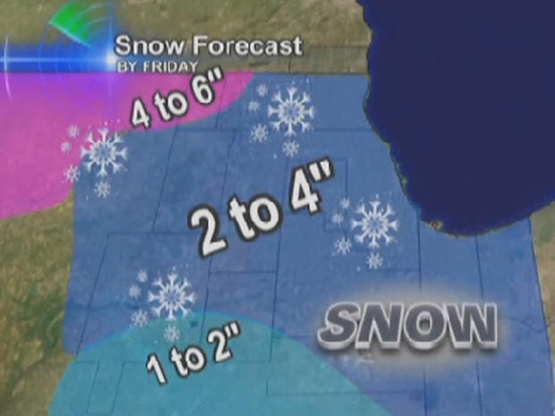
CHICAGO (CBS) -- A Winter Storm Watch has been issued for Thursday for the far western portions of Chicagoland, including DeKalb and McHenry counties.
Up to 4 to 6 inches of snow, plus powerful wind gusts, are possible for those areas west and north of Chicago. There is a Blizzard Warning in effect for parts of far northwest Illinois.
The totals may vary--depending on when the rain turns to snow.
The storm is expected to start as rain and switch to snow on Thursday afternoon. Snow totals for the area around the city will be anywhere from 2 to 4 inches.
Winds and blowing snow will be a factor for the Thursday afternoon rush hour. Winds are expected to increase--with gusts up to 50 miles per hour.
Right now the heaviest part of the storm is expected to slide from north to south and west of Chicago.
Wind gusts are expected to reach 40 to 50 miles per hour and temperatures begin to drop on Thursday.
After the storm moves past, temperatures with the colder on Friday, with highs only in the 20s.
The snow would be the latest measurable snow ever for Chicago. The previous record was Dec. 16, 1965. Chicago has also set a record for consecutive days without snow.