Wild Weather Night Expected; Strong Winds, Hail, 'Downpours' Possible
CHICAGO (STMW) -- Torrential downpours, cloud-to-ground lightning, wind gusts in excess of 70 mph, and hail as large as golf balls could all be in store for northern Illinois and northwest Indiana Sunday afternoon and evening, according to the National Weather Service.
Temperatures could also drop more than 40 degrees between Sunday afternoon and Monday night, according to the weather service.
The weather service has issued a wind advisory and a hazardous weather outlook for the area that stretches from Winnebago County through Cook, DuPage and Will, to Jasper and Benton counties in northwest Indiana.
There is a 20 percent chance of showers and thunderstorms Sunday afternoon in Chicago, according to the weather service, and the high temperature is expected to be near 80 degrees.
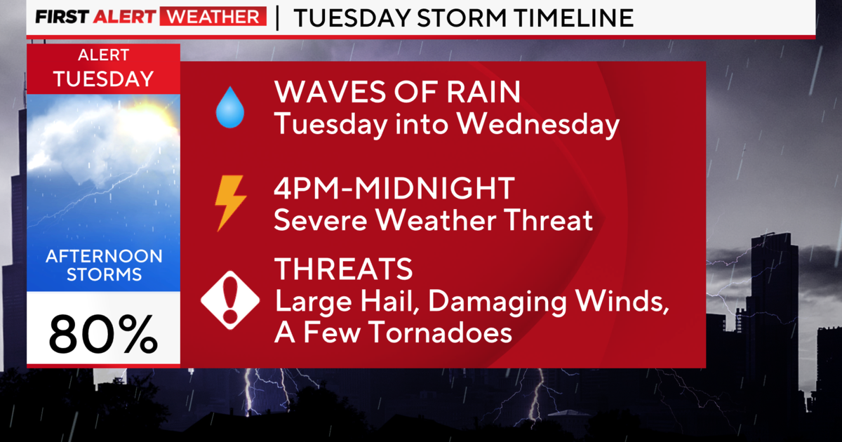
Sunday night, showers and thunderstorms are likely, mainly before 1 a.m. Some of the storms could be severe, the weather service says.
The weather service says these thunderstorms could be capable of producing hail up to the size of golf balls, damaging winds in excess of 70 mph, isolated tornadoes, torrential downpours, and frequent cloud-to-ground lightning. The primary severe weather risk appears to be damaging winds and large hail, according to the weather service, but given the extremely strong wind fields in association with this storm system, the potential will exist for isolated brief tornadoes. Outside of the thunderstorms winds this afternoon and evening could gust to between 40 and 50 mph.
The greatest threat for thunderstorms and potential severe weather appears to be Sunday evening, the weather service said.
A wind advisory is in effect until 1 a.m. Monday. A wind advisory means that sustained winds of 30 to 39 mph or gusts between 45 and 57 mph and likely, the weather service says. Winds this strong can cause minor property damage and driving may be difficult, especially in high-profile vehicles. Motorists should be alert and use caution driving.
New rainfall amounts between a tenth and quarter of an inch are expected in the Chicago area, except in the spots that will be hit by thunderstorms, where higher amounts are possible.
The area saw a preview of these conditions overnight, as thunderstorms brought frequent cloud-to-ground lightning, 40 mile-per-hour wind gusts, half-inch hail, and anywhere from one to two and a-half inches of rain late Saturday and early Sunday. According to the weather service, 1.42 inches of rain were recorded in Northbrook, 1.57 inches in Arlington Heights, 2.31 inches in Waukegan, and 2.35 inches in Libertyville.
Runoff from the storms will swell small creeks and streams and leave pools of water on roadways, in urban areas and below viaducts and underpasses, forecasters warn.
State Police in the Chicago area responded to about eight crashes because of slick, wet conditions early Sunday but no one was seriously injured, District Chicago Trooper Mark Hall said.
Illinois Department of Transportation crews were working to alleviate flooding at the bottom of ramps at the I-55 and Cicero Avenue interchange, but most other roadways are only seeing some minor standing water, state police said.
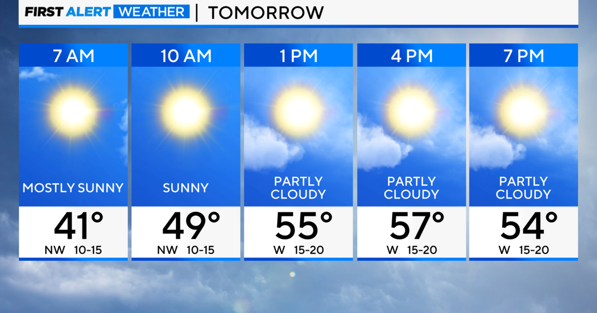
Monday there is a slight chance of showers between 7 a.m. and 1 p.m., with the temperature falling to around 55 by 5 p.m., the weather service says. It will still be breezy, with a west-southwest wind between 20 and 25 mph, and gusts as high as 35 mph. Monday night there will be patchy frost after 1 a.m., with a low temperature around 36 degrees.
(Source: Sun-Times Media Wire © Chicago Sun-Times 2012. All Rights Reserved. This material may not be published, broadcast, rewritten, or redistributed.)