Indiana State Police Launch Crash Prediction Map
CHICAGO (WBBM NEWSRADIO) -- The Indiana State Police launched an interactive online tool that tracks where and when vehicle crashes are most likely to occur in the state.
The Indiana Daily Crash Prediction map, developed by police and Management Performance Hub, is available to the public and is meant to help drivers make informed travel decisions, police said.
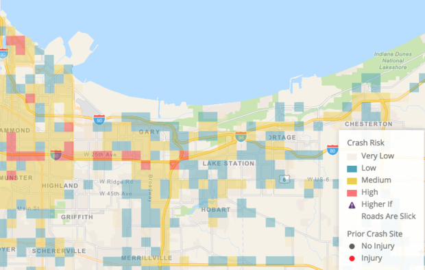
The map predicts likely crashes in any three-hour time window on the same day, using color shading to identify high and low risk areas. Areas in blue have a low probability of a crash, areas in yellow are at moderate risk and areas in red are most likely to experience a crash, according to police.
Locations where recent or major crashes have occurred are also shown on the map. Red dots represent crashes where someone was killed or injured, while gray dots represent crashes that involved property damage, police said.
Police said they hope this tool will help drivers plan for safer travel and will allow first responders to be proactive and allocate resources to more at risk areas.
The map is available on the Indiana State Police website.
(Source: Sun-Times Media Wire © Chicago Sun-Times 2018. All Rights Reserved. This material may not be published, broadcast, rewritten, or redistributed.)