LIVE UPDATES: Snow Covers Chicago Area Ahead Of Deep Freeze
CHICAGO (CBS) -- On the heels of two winter storms that brought more than 16 inches of snow combined to Chicago last week, more snow arrived on Thursday and a deep freeze is expected for the weekend.
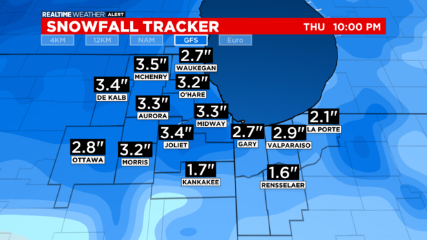
Parts of the Chicago area got more than 3 inches of new snow Thursday.
8:50 p.m.
On Thursday night, the last of the snow was moving out.
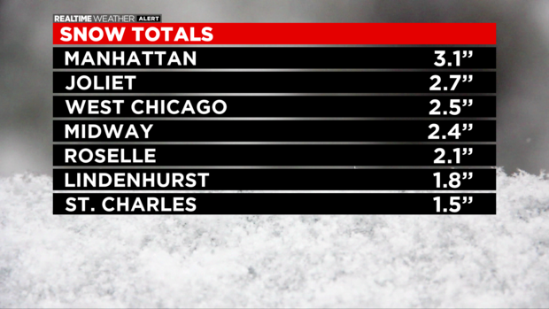
Snowfall totals reached 3.1 inches in the Will County community of Manhattan, 2.7 inches in Joliet, 2.5 inches in West Chicago, 2.4 inches at Midway International Airport, 2.1 inches in Roselle, 1.8 inches in Lindenhurst, and 1.5 inches in St. Charles.
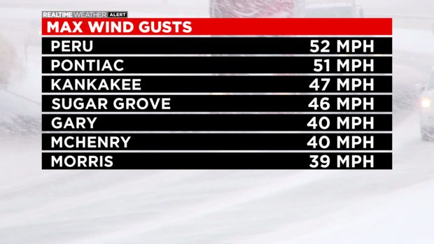
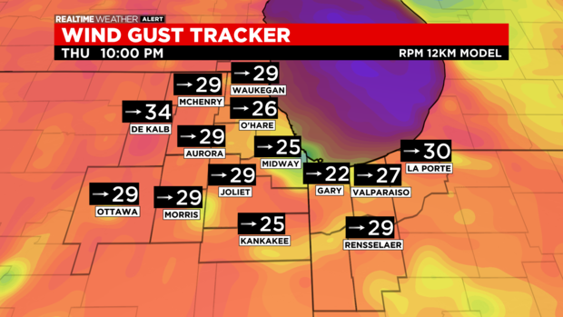
Bitter winds are accompanying the Arctic front. Winds this evening have been gusting 40-50 mph.
Winds gusted to 52 mph in Peru, 51 mph in Pontiac, 474 mph in Kankakee, 46 mph in Sugar Grove, 40 mph in Gary and McHenry, and 39 mph in Morris.
6:30 p.m.
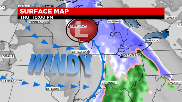
According to CBS 2 meteorologist Mary Kay Kleist, as the snowfall begins to end in the Chicago area, the temperatures will fall leading to a very cold weekend ahead.
5:45 p.m.
CBS 2 meteorologist Mary Kay Kleist says while the snow may taper off, the wind gusts are not slowing down.
4:35 p.m.
According to CBS 2 meteorologist Mary Kay Kleist, the Arctic front passes this evening, snow quickly ends in the 8:00 hour.
There will be very strong winds follow the frontal passage. Models are showing westerly wind gusts to 45 mph this evening.
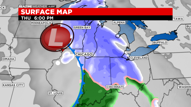
This front also opens the door for a brutally cold air mass that will lock in place for several days.
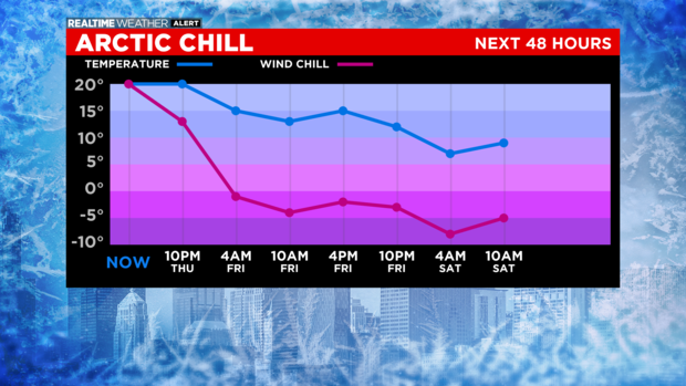
There was a pleasant high of 39 degrees today. By 10:00 Thursday night, feels like temps will be in the single digits. In fact, wind chills stay below zero the entire weekend!
4:05 p.m.
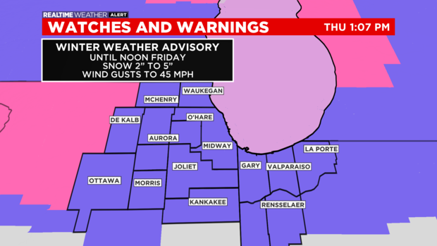
The National Weather Service has issued a Winter Weather Advisory through noon Friday. Heavy snow bursts Thursday afternoon will bring strong winds, poor visibility, and possibly even thunder.
4:00 p.m.
As the latest round of snow hits the Chicago area, airlines already have canceled nearly 300 flights at O'Hare and Midway airports, with more than 300 other flights delayed in the past 24 hours.
The Chicago Department of Aviation confirmed that 187 flights had been canceled at O'Hare as of 3:45 p.m., with another 94 canceled at Midway.
In the past 24 hours, 318 flights have been delayed at O'Hare, and another 36 have been delayed at Midway.
3:45 p.m.
Airlines have canceled 187 flights so far at O'Hare International Airport, as of 3:45 p.m., and another 94 flights at Midway International Airport.
In the past 24 hours, 318 flights have been delayed at O'Hare, and 36 have been delayed at Midway.
2:18 p.m.
The city of Chicago is deploying more 211 plows and salt spreaders, and plans to send its full fleet of nearly 300 trucks by the evening rush.
The city will deploy its full fleet of 287 trucks by the evening rush, with the focus starting on clearing the city's arterial streets and Lake Shore Drive.
City officials urged anyone who must travel Thursday to slow down and drive according to conditions. They also advised people to clear off their cars before extreme cold arrives this weekend.
To view the city of Chicago's snow fleet in real time visit the city's Plow Tracker website.
2:05 p.m.
According to the Chicago Department of Aviation, 159 flights had been canceled at O'Hare as of 2:05 p.m., with another 94 canceled at Midway.
In the past 24 hours, 223 flights have been delayed at O'Hare, and another 21 have been delayed at Midway.
1:57 p.m.
The National Weather Service has issued a Winter Weather Advisory through noon Friday.
According to CBS 2 meteorologist Mary Kay Kleist, heavy snow bursts Thursday afternoon will bring strong winds, poor visibility, and possibly even thunder.
Some parts of the southwest suburbs had already reported accumulations of an inch or more in the first hour of snowfall this afternoon, including 1.5 inches in Crest Hill, 1.5 inches in Frankfort, 1.3 inches in Romeoville, and 1 inch in Rockdale.
Accumulations of two to four inches are expected through Thursday evening, with isolated totals of five inches possible.
Friday's high will be only about 15°, and that might be the best we'll see through the end of next week, with some days seeing highs in the single digits, and temperatures occasionally falling below zero at night.
Wind chills could reach as low as 20 to 30 below zero at times over the next week.
Saturday and Sunday both could bring additional snow showers with a high of around 11° on Saturday and around 8° on Sunday.
Also From CBS Chicago: