Chicago Weather Alert: See Snow Totals From Groundhog Day Snowstorm; Lake-Effect Snow To Follow For Parts Of Area
CHICAGO (CBS) -- Parts of the Chicago area saw a foot or more of snow before the main system moved out Wednesday, and a lake effect system Thursday is expected to add even more accumulation in some areas.
A Winter Storm Warning was allowed to expire Wednesday evening, by which point the main system that brought all the snow throughout the day had moved out of the area.
But the second system could bring another 1 to 3 inches of lake-effect snow – particularly in central and northern Cook County including the city, as well as parts of DuPage County. A Winter Weather Advisory is in effect from 9 p.m. Wednesday to 6 p.m. Thursday for northern Cook County.
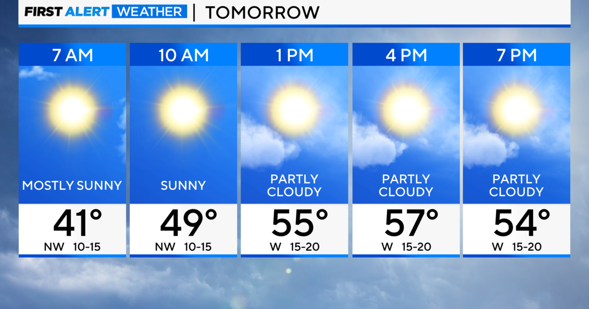
Some isolated spots may exceed more than 4 to 6 inches of new snow. The high for Thursday is 24.
There is also a chance of passing snow showers Friday evening. The high for Friday is 21.
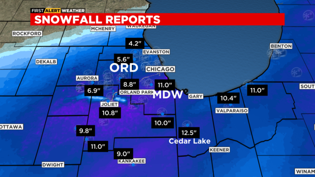
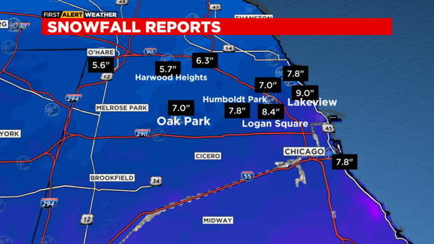
Here are totals reported by the National Weather Service for the snowstorm on Wednesday:
SOUTH HAVEN, IN - 13.5 INCHES (8:14 p.m.)
CEDAR LAKE, IN - 12.5 INCHES (4:20 p.m.)
FRANKFORT, IL - 11.5 INCHES (6 p.m.)
GARDNER, IL - 11.3 INCHES (4 p.m.)
DYER, IN - 11.2 INCHES (6 p.m.)
OAK LAWN, IL - 11.0 INCHES (4:30 p.m.)
BRAIDWOOD, IL – 11.0 INCHES (2:45 p.m.)
MICHIGAN CITY, IN - 11.0 INCHES (3 p.m.)
CREST HILL, IL - 11.0 INCHES (4:30 p.m.)
MIDWAY AIRPORT - 11.0 INCHES (4:30 p.m.)
CROWN POINT, IN - 11.0 INCHES (7 p.m.)
LOWELL, IN - 11.0 INCHES (7 p.m.)
HOMEWOOD, IL - 11.0 INCHES (6 p.m.)
JOLIET, IL - 10.8 INCHES (4 p.m.)
MIDLOTHIAN, IL - 10.8 INCHES (3:38 p.m.)
PEOTONE, IL - 10.7 INCHES (6 p.m.)
CHANNAHON, IL - 10.7 INCHES (6 p.m.)
COAL CITY, IL - 10.5 INCHES (1:15 p.m.)
TINLEY PARK, IL - 10.5 INCHES (3:04 p.m.)
EAST BROOKLYN, IL - 10.1 INCHES (8:50 a.m.)
BURR RIDGE, IL - 10.0 INCHES (6 p.m.)
HICKORY HILLS, IL - 10.0 INCHES (6 p.m.)
WESTVILLE, IN - 10.0 INCHES (1:27 p.m.)
CHESTERTON, IN - 10.0 INCHES (9:57 a.m.)
LYNWOOD, IL - 10.0 INCHES (10:30 a.m.)
ROMEOVILLE, IL - 10.0 INCHES (4 p.m.)
VALPARAISO, IN – 10.0 INCHES (11:40 a.m.)
STEGER, IL - 10 INCHES (3 p.m.)
CARBON HILL, IL – 9.8 INCHES (3:33 p.m.)
HOMEWOOD, IL - 9.8 INCHES (1:10 p.m.)
BRADLEY, IL - 9.5 INCHES (10:22 a.m.)
NEW LENOX, IL - 9.5 INCHES (8:57 a.m.)
HOMER GLEN, IL - 9.3 INCHES (11:33 a.m.)
PEOTONE, IL – 9.3 INCHES (12 p.m.)
MOKENA, IL - 9.2 INCHES (3 p.m.)
LAKEVIEW, CHICAGO, IL - 9.0 INCHES (5:30 p.m.)
KANKAKEE, IL - 9.0 INCHES (3 p.m.)
PLAINFIELD, IL - 9.0 INCHES (1:10 p.m.)
WESTMONT, IL - 9.0 INCHES (3 p.m.)
STREATOR, IL - 9.0 INCHES (12 p.m.)
LEMONT, IL - 9.0 INCHES (11:35 a.m.)
DOWNERS GROVE, IL - 8.8 INCHES (3:30 p.m.)
OSWEGO, IL - 8.7 INCHES (3:30 p.m.)
MORRIS, IL - 8.5 INCHES (12:05 p.m.)
BRIDGMAN, MI - 8.5 INCHES (1:41 p.m.)
LOGAN SQUARE, CHICAGO, IL - 8.4 INCHES (3:05 p.m.)
NAPERVILLE, IL - 8.0 INCHES (3:22 p.m.)
DOUGLAS, CHICAGO, IL - 7.8 INCHES (2:30 p.m.)
PARK FOREST, IL - 7.5 INCHES (9:30 a.m.)
PORTAGE PARK, CHICAGO, IL - 7.0 INCHES (5:30 p.m.)
OAK PARK, IL - 7.0 INCHES (3 p.m.)
SCHERERVILLE, IN - 7.0 INCHES (9:22 a.m.)
WILLOWBROOK, IL - 7.0 INCHES (12:45 a.m.)
HUMBOLDT PARK, CHICAGO, IL - 6.5 INCHES (12:30 p.m.)
ST CHARLES, IL - 6.5 INCHES (12 p.m.)
SOUTH SHORE, CHICAGO, IL - 6.4 INCHES (4:30 p.m.)
JEFFERSON PARK, CHICAGO, IL - 6.3 INCHES (3:00 p.m.)
LOMBARD, IL - 6.0 INCHES (12 p.m.)
ROSELLE, IL - 6.0 INCHES (12 p.m.)
O'HARE AIRPORT - 5.6 INCHES (4 p.m.)
OAK FOREST, IL - 5.5 INCHES (7:45 a.m.)
NORTH AURORA, IL - 5 INCHES (5 p.m.)
BATAVIA, IL - 5 INCHES (3 p.m.)
EDGEWATER, CHICAGO, IL - 5 INCHES (9:15 a.m.)
Here are some maps from Chief Meteorologist Albert Ramon showing snow totals for multiple areas of the city and suburbs.