Severe Storm Threats End, But Flooding Risks Remain Along Des Plaines And Fox Rivers
CHICAGO (CBS) -- Storms have cleared out for most of the Chicago area, but flooding risks remain along parts of the Fox and Des Plaines Rivers for the next few days as runoff continues to swell local waterways.
According to the National Weather Service, lingering showers are possible Tuesday morning south of Interstate 80, with minimal thunderstorm activity, but there is no risk of severe weather.
However, flood advisories have been issued for sections of the Des Plaines River in the wake of Monday's storms, due to high water levels in suburban Lincolnshire, Riverside, and River Forest. While the river is not expected to reach flood stage in those areas, it is likely to continue rising through early Wednesday morning, as runoff continues to flow into the river.
Flood warnings also have been issued for the Des Plaines River near Gurnee, Russell, and Des Plaines, as it could rise above flood stage Tuesday and Wednesday in those areas, but severe flooding is not expected.
Flood warnings also have been issued along the Fox River near New Munster, Algonquin, and Montgomery, where the river was at or above flood stage and still rising Tuesday morning.
While those flood risks will remain in place for the next few days before the rivers start to recede, no significant rainfall is expected the next few days.
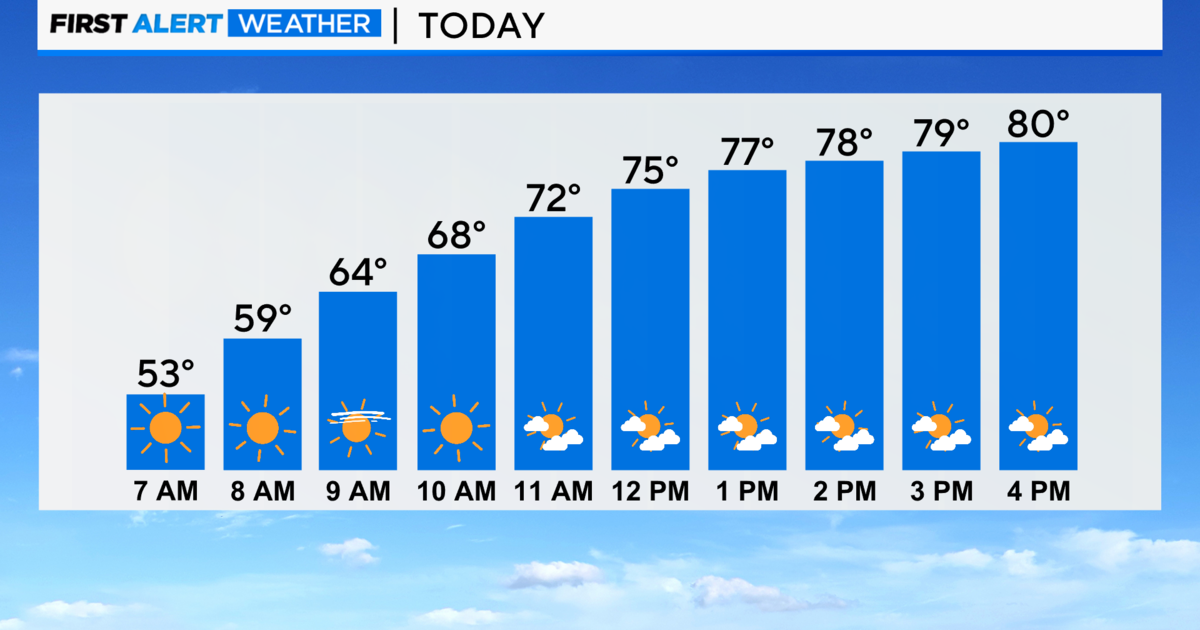
In the wake of Monday's storms, the Chicago area can expect muggy conditions and some minor fog. Temperatures likely will linger in the 60s to low 70s on Tuesday, but get much warmer the rest of the week, with beautiful sunny skies and his reaching near 80 from Wednesday through Saturday.
Chances for thunderstorms return late Saturday, with cooler temperatures returning Sunday.