Blizzard 2011: A View From Space Shows Sheer Size Of Storm
CHICAGO (CBS) -- We have a good idea what the Blizzard of 2011 looks like on the ground: Officially, 20.2 inches fell, but some towns got even more, and the snow piles seem to touch the sky.
But to get a true measure of the size of this storm, you need to go to space.
The image above was taken by a NASA satellite at 3:31 p.m. on Tuesday--just as the storm started to hit Chicago.
It measures 1,240 miles from west to east and was created when arctic air from Canada collided with moist air from the Gulf of Mexico. The storm became more organized as those two forces combined overnight, generating snowfalls of 3-4 inches per hour and wind gusts above 50 mph. The perfect mixture for a blizzard!
The image below was taken on Wednesday. The turquoise color shows areas that are covered by snow. (The exception is the light blue over Alabama, South Carolina and Georgia.)
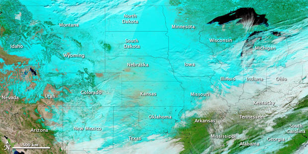
The National Weather Service said 21 states, from New Mexico to New England--got at least five inches of snow from this storm. Illinois declared a state of emergency as the blizzard turned out to be the third-worst on record.