Chicago Weather Alert: Snow Pounds Chicago Area With Totals Of 5 Inches For Some Areas
By Albert Ramon and Mary Kay Kleist
CHICAGO (CBS) -- Snow pounded the Chicago Thursday afternoon and evening, intensifying during the evening rush to make roads treacherous.
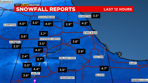
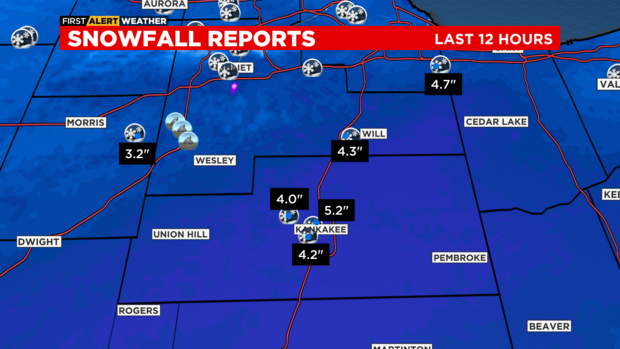
Snowfall totaled five inches in parts of the area.
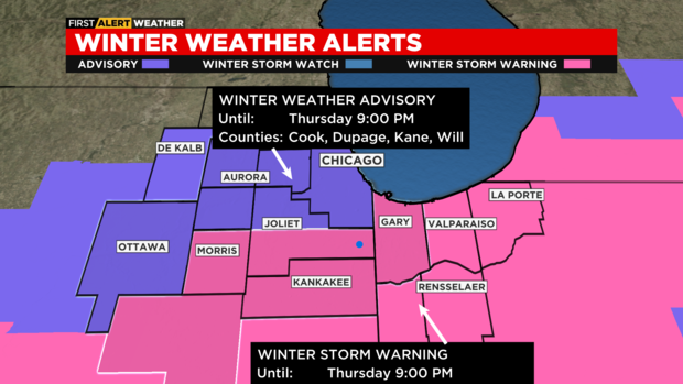
A Winter Storm Warning was in place well into the evening for areas to the south and southeast on the city. This warning does not include Cook County. Cook County was, however, under a Winter Weather Advisory.
The Winter Storm warning extended all the way from Kansas City through Quincy, Illinois, and northeast to metro Detroit. For Newton and Jasper counties in Indiana, it has been extended in time until midnight.
Snowfall amounts ranged from 2 to 4 inches over much of the Chicago Metro. The heaviest snowfall reports have been in Kankakee County with as much as 5 inches in Bradley. Snowfall reports have been slow to come in for Northwest Indiana, but we may see a few spots exceed 6 inches, especially in Porter County near the lake.
The snow began falling in the far southern suburbs shortly before noon. The most intense snow in Chicago was over by around 7 p.m.
CBS 2 Meteorologist Mary Kay Kleist reported at 4 p.m., just as the afternoon rush began, snow was falling at a rate of up to an inch per hour in a band from Ottawa through Aurora northeast to Waukegan and Zion. The same was true with a swath that moved into central Kankakee County. The severity kept picking up in many areas, including the south suburbs and Northwest Indiana.
On Thursday afternoon, blizzard conditions developed south of a line from Pontiac, Illinois, to Valparaiso, Indiana.
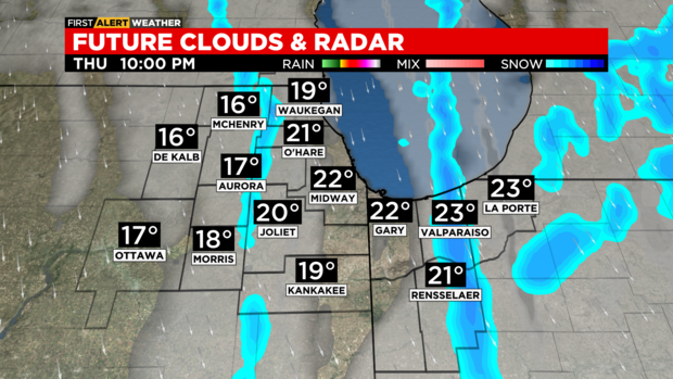
Snowfall rates were decreasing by midevening as the winter storm moves to the east. Lake effect snow remains possible through the late evening for parts of Northwest Indiana.
A gusty north wind allowed for blowing and drifting snow through the evening.
Roads in the area were in terrible shape, with whiteout conditions and strong winds creating visibility near zero at times.
Maria Castaneda of the Illinois Department of Transportation warned during the evening rush that anyone who hit the roads would be in for a messy commute. She advised that the blowing wind was causing near-whiteout conditions in parts of the area.
Castaneda also warned that slick spots will abound as the temperature drops – especially on bridges and overpasses. She said IDOT trucks are out there, but will be stuck in traffic like everyone else – and IDOT plows should be given room.
Conditions in Indiana became treacherous by early afternoon and kept getting worse as the evening went on. Interstate 65 south was packed with snow and all lanes were closed at mile marker 234 in Newton County because of a crash.
Farther south, in Monticello, Indiana, flooding is becoming a major concern. Here is a look at Oakdale Dam along the Tippecanoe River.
Downstate, dozens of vehicles were reported to be involved in a massive pile-up east of Peoria, according to Illinois State Police. Initial reports said as many as 100 cars are involved in the crash on I-39, which was closed down near Mile Marker 14.
Interstate 39 southbound will be closed for up to 12 hours.
Back in Chicago, the Department of Streets and Sanitation has dispatched 287 plows to clear snow and spread salt through the afternoon and into the evening. The plows will focus on DuSable Lake Shore Drive and other main roads.
To view watch the snow fleet in real time, go to this link.
Meanwhile, hundreds of flights were canceled at O'Hare and Midway international airports Thursday afternoon as snow pounded the Chicago area.
As of 3:25 p.m., the Chicago Department of Aviation reported average delays of 37 minutes at O'Hare, and 301 cancellations. Delays were reported at fewer than 15 minutes at Midway, but there were 142 cancellations.
The Federal Aviation Administration attributed the ground delays at O'Hare to snow and ice.
Winds will decrease by the early morning hours of Friday with temperatures in the single digits and low teens.
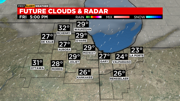
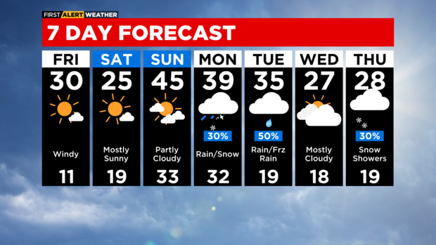
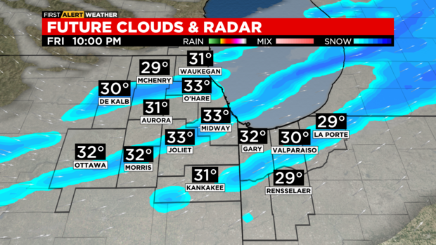
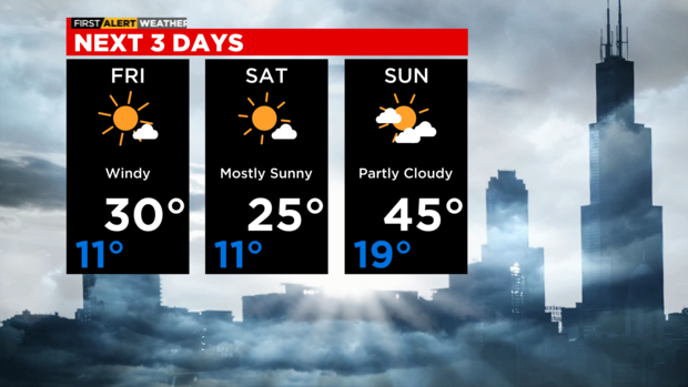
It will be mostly sunny and windy Friday with highs in the upper 20s and low 30s. A clipper system will quickly pass through the area on Friday evening allowing for scattered snow showers. A dusting to two tenths of an inch of snowfall is possible.
It will also be mostly sunny and mid 20s on Saturday. A strong southwest wind will boost highs to the mid 40s on Sunday.
A rain and snow mix is possible for Monday with highs near 40 degrees. Rain and freezing rain are possible for Tuesday with temperatures in the low to mid 30s.