LIVE UPDATES: Severe Weather Brings Tornado Warnings, Drenching Rain To Chicago Area; Tornado Sighted Near Crete
CHICAGO (CBS) -- Severe weather swept into the Chicago area on Saturday afternoon, bringing heavy rain and tornado warnings right to the center of the city.
10 p.m. Neighbors tell CBS 2's Steven Graves the storms left trees snapped and roads blocked in Dyer, Indiana and surrounding areas. Neighbors heard tornado sirens multiple different times, but they also said the worst winds and rain came before one siren was heard.
10 p.m. The storms Saturday dumped heavy rain that overwhelmed drainage systems in South Chicago Heights. Streets in some neighborhoods were impassable and some cars ended up stranded in flooded parking lots.
The combination of wind and rain also took out several trees in nearby Homewood.
7:34 p.m. ComEd reported there were more than 100 customers without power in Chicago as of 7:30 p.m., primarily on the South Side.
7:29 p.m. A tree fell on a woman during the storms in south suburban Steger Saturday, officials said early in the evening. The Steger Fire Department said the woman had mostly scratches and bruises, but might have suffered a broken leg, and was taken to Franciscan Health in Dyer, Indiana.
6:25 p.m. The Eisenhower Expressway has reopened in both directions.
6:01 p.m. The severe storms have been blamed for a roof collapse at a commercial building at 7615 W. Irving Park Rd. in Dunning. The Department of Buildings was on the scene early Saturday evening. The business was an auto body shop and was closed. No one was injured.
5:26 p.m. A new tornado warning in effect for northeast Porter and northwest Lake County in Indiana until 5:45 p.m. The site of this tornado warning is close to the lakefront.
4:51 p.m. The White Sox' Saturday afternoon game at Guaranteed Rate Field has been postponed due to severe weather. A doubleheader is set for Sunday -- with a nine-inning game followed by a second seven-inning game.
4:43 p.m. A new tornado warning has been issued for northwestern Kankakee County until 5:15 p.m., including parts of the city of Kankakee.
4:41 p.m. With severe weather around the state, Gov. JB Pritzker advised that everyone follow all warnings and watches and make sure to keep themselves and their families safe.
4:38 p.m. A new funnel cloud has been reported near Crete. The storm is following the same path as an earlier tornadic storm through Dyer in Northwest Indiana.
4:28 p.m. A new tornado warning is in effect for southeast Cook County, east central Will County, and west central Lake County, Indiana until 5 p.m.
4 p.m. A tornado warning has been issued for parts of Will, Kankakee, Grundy, and Livingston counties. Warnings were issued for multiple dangerous cells that are following each other. The rotating storms are likely wrapped in rain with the torrential downpours.
CBS 2 Meteorologist Mary Kay Kleist says residents in Manteno and Peotone should take cover. The rotation is tighter with this system than some of the earlier ones.
3:25 p.m.: There is a report of debris in the road in Crete, and a tree down on a house on Merioneth Drive in Crete.
3:07 p.m.: The Belmont Avenue underpass under Jean Baptiste Point Du Sable Lake Shore Drive was left flooded following the heavy rain earlier in the afternoon.
2:34 p.m.: A severe thunderstorm warning has been issued for northeastern Newton, southern Porter, southeastern Lake, and northern Jasper counties in Indiana until 3:15 p.m. CBS 2 Meteorologist Mary Kay Kleist reports this storm system is accompanied by torrential rains, and while there is not a tornado warning, people are still advised to take cover given how easily rotation has been happening.
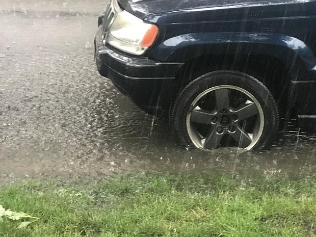
2:25 p.m.: The cell that moved through DuPage and Cook counties around noon brought 3 1/2 inches of rain to the city of Chicago.
2:16 p.m.: A funnel cloud and a possible tornado has been confirmed over suburban Crete.
A new tornado warning was issued until 2:45 p.m. Saturday for Lake County, Indiana, and parts of southeast Cook and east central Will counties.
CBS 2 Meteorologist Mary Kay Kleist said the tornado was likely wrapped in drenching rain.
The storm that produced the tornado was headed toward Dyer, Griffith, and Gary.
2:11 p.m.: A new tornado warning has been issued for southern Cook County as well as Will County and Lake County, Indiana until 2:45 p.m.
2:07 p.m.: a tree came down and blocked Jean Baptiste Point Du Sable Lake Shore Drive near 63rd Street along Jackson Park during the storms.
1:37 p.m.: Heavy rain fell rapidly in the Chicago area with 2 to 3 inches all at once during the severe storms, CBS 2 Meteorologist Robb Ellis reported.
1:32 p.m.: A severe thunderstorm warning has now been issued until 2 p.m. for far southeast Cook and northeast Will counties and northern Lake County, Indiana. CBS 2 Meteorologist Robb Ellis reports there is come concern about rotation over Northwest Indiana, but no tornado warning has been issued.
1:07 p.m.: Illinois State Police warn of standing water on the Eisenhower Expressway eastbound and westbound at Des Plaines. Eastbound traffic was being diverted off at Des Plaines and westbound traffic was being diverted off at 1st Avenue. ISP warned to avoid the area.
1:01 p.m.: Video shows rain coming down in buckets at Artesian and Wabansia avenues in Bucktown.
12:58 p.m.: Following the heavy rain, police warned people to be cautious around viaducts. There were also reports of flooded basements in the city.
12:34 p.m.: The drenching rain from the storms brought street flooding to Bucktown early Saturday afternoon.
12:33 p.m.: CBS 2 Meteorologist Tammie Souza has pinpointed another storm of interest in the south suburbs near Harvey.
A severe thunderstorm warning has been issued for central Will County, southeastern Cook County, and northwestern Lake County, Indiana.
12:31 p.m.: A flash flood warning has also been issued for parts of the eastern Cook, central DuPage, and northwest Will County until 6:15 p.m.
12:11 a.m.: Emergency warning sirens were heard in Grant Park amid the tornado warning.
11:49 a.m.: A tornado warning was issued for parts of the City of Chicago until 12:15 p.m.
The National Weather Service reported that at 11:49 a.m., a severe thunderstorm capable of producing a tornado was spotted over East Garfield Park and West Town.
The system moved northeast toward Lakeview, Uptown and Edgewater. The NWS reported the rotation moved out over the northern part of the Loop area.
A separate tornado warning was issued for southwest Will County just to the south and east of Joliet until noon, and a third was issued for southern Grundy County and Livingston County until 12:30 p.m.
Ellis reported the Grundy County storm system had the most severe rotation and was the most dangerous of the systems.